
The Satellite That Shouldn't Exist Is Taking Pictures
Albedo's ultra-low satellites can photograph anything, anywhere, at smartphone-level detail.

Albedo calls itself the provider of "aerial-quality imagery from space" — in plain English, they take photos from satellites that are as detailed as those from airplanes or drones. This seemed impossible just five years ago. Yet when Topher Haddad, Ayjay Lasater and Winston Tri watched their Clarity-1 satellite establish first contact just fourteen hours after its March 17, 2025 SpaceX launch, they had proven something revolutionary:
A commercial satellite flying just 200 miles above Earth — 10 times closer than traditional satellites — could actually survive and thrive where atmospheric drag should theoretically destroy spacecraft within weeks.1
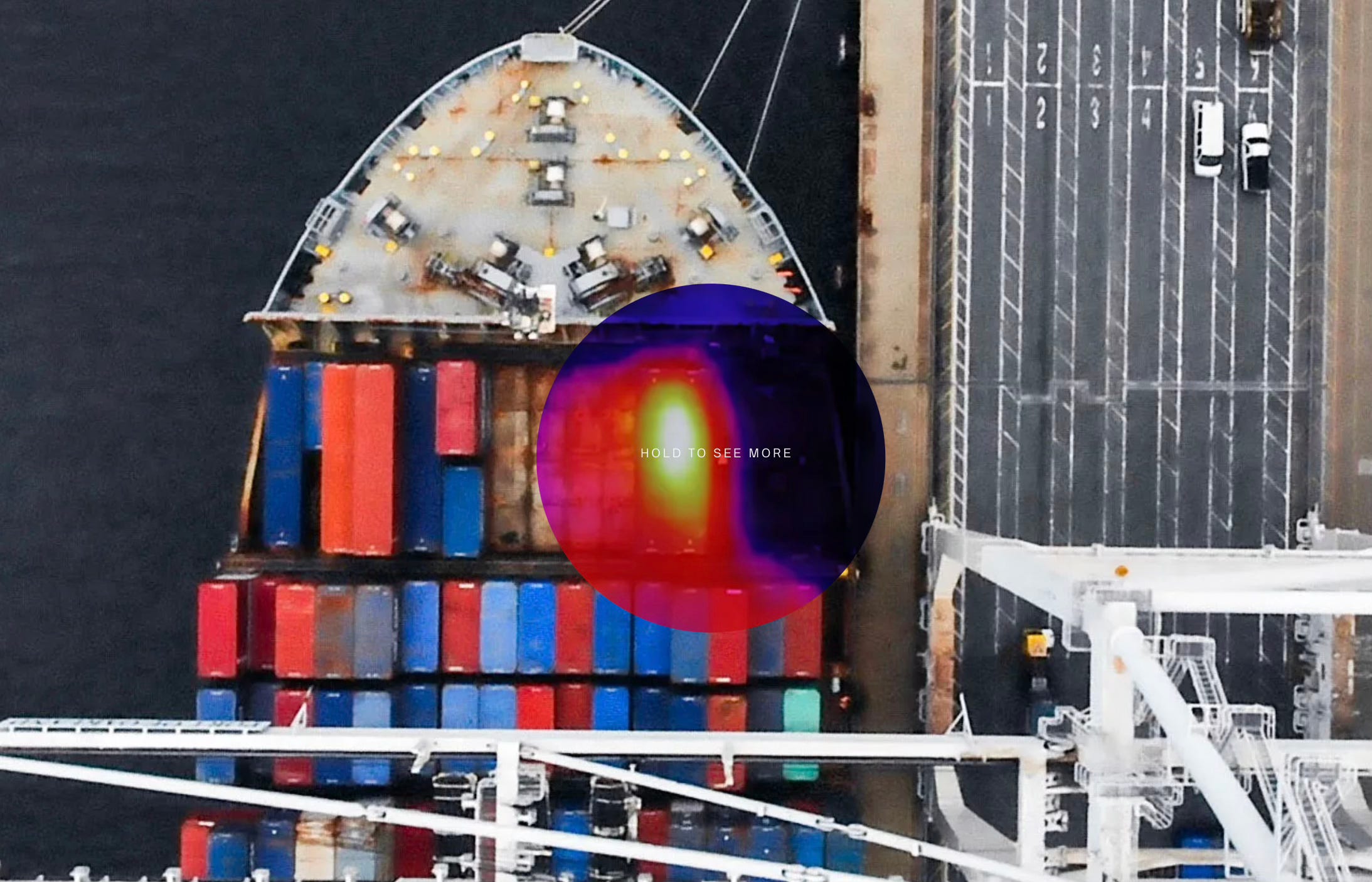
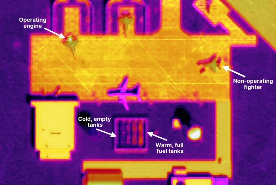
The Denver-based company had just achieved what industry veterans said would cost billions: delivering images from space so detailed you can identify objects as small as a smartphone — technically called "10 centimeter visible imagery" — plus heat-sensing thermal imagery.
This resolution was previously exclusive to classified government spy satellites or aircraft flying overhead.2 With $97 million in funding, binding contracts worth $15 million from early customers, and a $12 million Strategic Funding Increase (STRATFI) contract from the Air Force Research Laboratory, Albedo has sparked a new space race to the bottom — literally.3
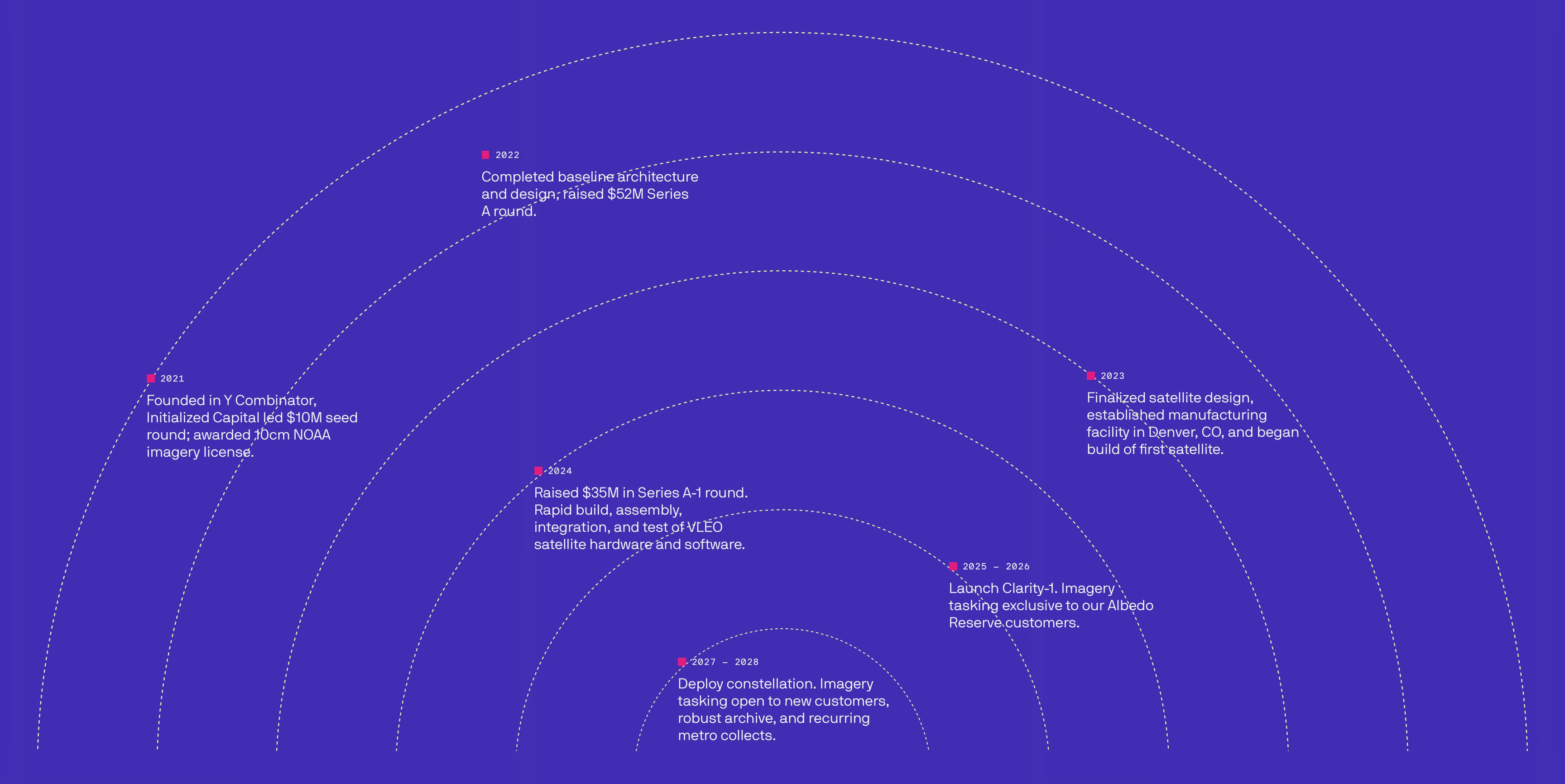
Founded in 2020 through Y Combinator by former Lockheed Martin engineers who worked on classified reconnaissance satellites, Albedo has evolved from a Trump tweet inspiration4 into something unprecedented: a company commercializing an entirely new zone of space called Very Low Earth Orbit (VLEO) — the atmospheric danger zone that the space industry had written off as impossible.5
The Trump Tweet That Changed Everything
In 2019, then-President Trump tweeted a remarkably detailed satellite image of an Iranian missile failure. The space intelligence community immediately recognized something extraordinary: this wasn't commercial imagery.
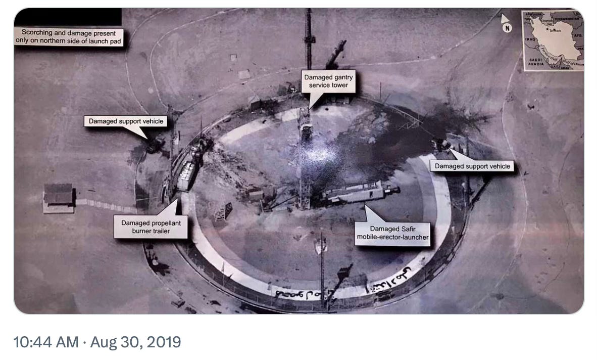
"People soon realized that this was way higher resolution than any commercial imagery available at the time. We estimated it to be 10cm per pixel, measured on the ground," Haddad recalled in a 2022 interview.6
"In the industry, it sparked a whole conversation about whether it'd be feasible to do this commercially. Would there be a market for it?" - Topher Haddad
Industry experts concluded there would indeed be a gigantic market — but conventional wisdom held it would require billion-dollar, school-bus-sized satellites. Haddad, then a systems engineer at Lockheed Martin working on top-secret remote sensing satellites, saw a different path: "With my background, I started thinking about the architectural design, and how it could look like if we were able to fly satellites lower."
This insight — that proximity could substitute for size — became Albedo's founding thesis. By operating in Very Low Earth Orbit (VLEO) at 250-450 kilometers instead of traditional Low Earth Orbit at 500-2000 kilometers, smaller satellites with modest optics could achieve spy-satellite resolution at a fraction of the cost.
Why Flying Low Is So Hard
Most satellites orbit at 1,200-22,000 miles above Earth, safely above the atmosphere. The International Space Station flies at about 250 miles up. Albedo's satellites? They're flying at just 170-270 miles — so low that Earth's atmosphere is literally trying to drag them down. At these altitudes, atmospheric drag increases exponentially, causing normal spacecraft to burn up and crash within 2-4 weeks without constant rocket thrust to stay aloft.
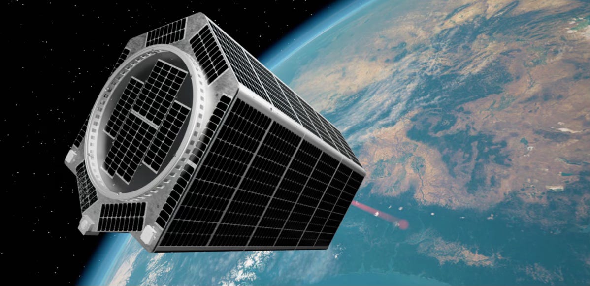
Albedo's solution: build heavy. Clarity-1 weighs 530 kilograms (about 1,170 pounds) — deliberately dense to resist atmospheric drag while using electric propulsion for continuous orbit maintenance.7
The technical challenges cascade from there. "There's stability, which is making sure your picture isn't blurry. There's agility, so being able to rapidly repoint at different targets that you're trying to image as you're passing over very quickly... And then there's accuracy, knowing exactly where you're pointed," Haddad detailed to TechCrunch.8 At VLEO altitudes, satellites move faster relative to Earth's surface, requiring unprecedented precision in guidance, navigation, and control systems.
But the payoff justifies the engineering complexity.
"If we can cut that distance in half from space, we can shrink the size of the diameter and get high resolution at a price point that works for the commercial market," Haddad explained in a 2025 Payload Space interview.9
Albedo's achievement isn't just incremental improvement — it's a paradigm shift that makes aerial-quality imagery available globally, on demand, from space.
The Race to Fly Lower: Why Everyone Suddenly Wants In
Albedo's March 17, 2025 launch coincided with an inflection point in the Earth observation market. By 2030, businesses will account for over 50% of global Earth intelligence spending, up from 30% today, driven by enterprises discovering that high-resolution imagery plus AI equals transformative insights.10
The numbers are staggering: The global very low earth orbit (VLEO) satellite market is projected to reach $1.502 billion by 2034 from $10.4 million in 2025, growing at 73.9% per year.11 This explosive growth reflects a fundamental shift in how businesses view satellite data.
Albedo's early customers reveal the breadth of demand — and remarkably, every available photo slot for US customers is already booked solid through 2027, before the satellite has even taken its first commercial picture.12 AiDash helps mitigate the risk and impact of disasters like storms and wildfires from space. Open Grid Europe manages over 12,000 km of pipelines using Albedo's imagery as "the first space-based component of their current aerial monitoring fleet." Japan Space Imaging, the leading provider of satellite imagery in Japan since 1998, brings Albedo products to the Asian market. Even hedge funds are buying capacity, using ultra-high resolution imagery for "assessing events across the globe in a timely manner."
"It's a mix of customers who already buy satellite imagery and want high res on top of that, or a lot of these customers only fly helicopters to do this, and think 10-cm imagery is enough to replace that," Haddad told Payload Space.13
The economics are compelling: why maintain a fleet of aircraft when satellites can provide equivalent or better imagery globally, weather-independent, without pilots or fuel?
The company's "Albedo Reserve" program lets customers pre-purchase imaging capacity, guaranteeing access without conflicts or priority disputes. By February 2025, nineteen companies had already joined Reserve, claiming significant portions of Clarity-1's imaging schedule through mid-2027.
Why the Military Is Paying Attention
While commercial applications drive volume, defense and intelligence customers provide validation and funding. Albedo's Strategic Funding Increase opportunity by the Air Force Research Laboratory, with funding of $12 million announced March 3, 2025, isn't just about money — it's about proving VLEO's military value.14
The ability to capture thermal infrared at night transforms intelligence gathering — revealing activity patterns invisible to traditional optical satellites.
The National Reconnaissance Office and National Air and Space Intelligence Center partnerships validate what industry observers suspected: VLEO represents a step-change in persistent surveillance capabilities.15 With planned five-times-daily revisit rates from the full 24-satellite constellation, Albedo could enable near-real-time tracking of ground movements — a holy grail for military intelligence.
The Economics: How Flying Lower Actually Costs Less
Albedo's cost structure defies traditional satellite industry assumptions. By operating closer to Earth, the company achieves multiple cost advantages: smaller rockets can reach VLEO (saving millions on launch costs), smaller cameras deliver equivalent resolution (saving millions on optics), and shorter mission lifetimes of 3-5 years versus 7-15 for traditional satellites enable faster technology upgrades.
The investor roster — spanning from Bill Gates' climate fund to defense-focused Shield Capital to strategic investor Booz Allen Ventures — reflects how this technology serves both commercial businesses and military/intelligence agencies (what the industry calls "dual-use").
With Clarity-1 now operational at 320km altitude and descending to its target 274km orbit, Albedo has de-risked the fundamental technology.16 The question shifts from "can VLEO work?" to "how fast can they scale?"
The Vision: A World Where Everything Is Visible
Albedo imagines a world where commodity traders track individual shipping containers, insurance companies assess roof damage within hours of storms, and environmental groups monitor deforestation tree by tree. The combination of 10-centimeter resolution and AI-powered analysis could make Earth's surface as searchable as the internet.
Albedo's successful VLEO demonstration has implications beyond Earth observation. China has already begun launching satellites into VLEO, with "ultra-fast remote sensing and communication services" pushing investment in VLEO constellations.17 The European Defense Agency committed €10 million to research satellites that can maneuver between LEO and VLEO. A new orbital regime is opening for business.
For investors, Albedo presents a compelling opportunity: they've proven low-flying satellites work, captured blue-chip customers across commercial and defense markets, and positioned themselves as the clear leader in a market growing at 74% annually. The company's current fundraising round values them at $285 million — up from $150 million just two years ago — reflecting this momentum.18
I am excited to have invested in Albedo through Lombard Street Ventures (LP), given their potential to fundamentally transform Earth observation. While Albedo's current constellation is limited to 24 satellites, the principles they've proven — that proximity beats size, that atmospheric drag is manageable, that 10-centimeter resolution changes everything — could reshape how we observe our planet.
The most audacious claim might also be the most accurate: Albedo isn't just building satellites. They're building infrastructure for a transparent world where aerial-quality imagery from space becomes as ubiquitous as weather data. In an era demanding unprecedented visibility into supply chains, climate change, and geopolitical movements, that might be exactly the infrastructure we need.
If you enjoyed this piece, you might also be interested in my analysis of Lambda's infrastructure play for the AI revolution, which explores how specialized platforms are disrupting established cloud giants.
Roberto Veronese, an investor and limited partner (LP) in several venture capital funds, including Lombard Street Ventures. Lombard Street Ventures made early investments in Albedo and provided follow-on capital in Albedo’s Series A funding round.
"Albedo's Clarity-1 Satellite Successfully Launches, Establishes First Contact, and Enters VLEO-Specific Protect Mode," Business Wire, March 17, 2025
"Albedo (10cm)," Satellite Imaging Corp.
"Albedo Selected for $12M STRATFI Contract," Business Wire, March 3, 2025
Donald Trump’s tweet, August 30, 2019
“Albedo: Capturing the highest resolution satellite imagery," Y Combinator
"#45 Topher Haddad: To infinity and beyond," Venture Insider, September 6, 2022
“Albedo catches Space Force eyes with ultra-high fidelity imagery from very low satellites," Breaking Defense, April 27, 2023
"Albedo closes $35M at boosted valuation to build satellites that orbit very, very close to Earth," TechCrunch, January 23, 2024
“A Q+A with Albedo's Topher Haddad," Payload Space, September 8, 2022
"Very Low Earth Orbit (VLEO) Satellite Global Market Forecasts 2025-2034," Business Wire, August 1, 2025
"Upcoming Launch of Clarity-1 and Albedo's Early Customers," Albedo, June 12, 2024
"Albedo Will Launch Clarity-1 In February," Payload Space, June 12, 2024
See #3.
"NRO Awards Albedo Stage II Contract for Thermal/Infrared Imagery," SpaceWatch.GLOBAL, August 2025
See #1.
“Satellite Limbo: VLEO's Take Sats to New Lows," Freedom Technologies Inc., April 4, 2024
“Satellite imagery startup Albedo, which can track people from space, is raising a new round at a $285 million valuation," Yahoo Finance, April 23, 2025